Who Owned the Silver Beneath Virginia City?
By James Randall
In January 1867, a federal judge in Nevada confronted a problem no ordinary property lawsuit could easily solve. William B. Thornburgh claimed that the Savage Mining Company was taking mineral from ground that belonged to him. Savage disputed the claim. The decisive evidence lay not on a surveyor’s table or along a fence line, but inside the mountain.
Judge Alexander W. Baldwin ordered Savage to open its underground workings to Thornburgh and a survey party of as many as nine men. They could inspect and measure the disputed ground for up to five working days. Savage protested that the interruption would cost at least $500 a day. The judge allowed the survey to proceed.
The episode reveals one of the strangest facts about property in nineteenth-century Virginia City: a boundary drawn on the surface did not necessarily tell you who owned the ore hundreds or thousands of feet below it.
A City Above, Another Geography Below
On the streets of Virginia City, property could be described in familiar terms: a lot, a building, a business, a street frontage. Underground mining demanded another kind of geography. The Comstock Lode descended through the mountain as a complicated mineralized structure, and the great mining companies followed it with shafts, drifts, crosscuts, stopes, and winzes.
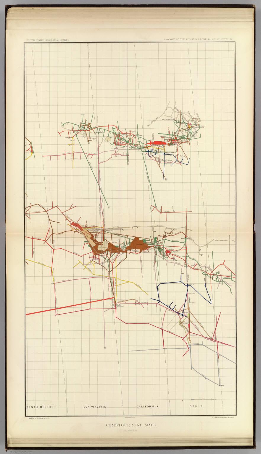
George F. Becker’s federal survey of the Comstock, conducted in 1880 and 1881 and published in 1882, shows how complicated that underground world had become. His atlas drew upon official mine surveys and mapped workings at successive hundred-foot levels, in places reaching roughly 3,000 feet below the surface. What looked orderly from C Street became a tangled, multilevel network underground.
The mine claims themselves could be narrow. Savage controlled about 800 feet along the Comstock. Ophir’s principal claim was about 675 feet. Union began with only about 302 feet along the lode, yet its workings eventually reached approximately 3,350 feet in depth. A strip measured in hundreds of feet at the surface could therefore become a legal and engineering problem extending thousands of feet downward.
The Law Followed the Vein
The source of much of the confusion was the legal importance of the mineral vein itself. Before Congress created a more standardized federal mining system, western miners developed local customs for staking and working claims. The federal Mining Act of 1866 recognized many of those customs and also acknowledged the right of a claimant to follow a vein with its dips, angles, and variations into adjoining ground.
The General Mining Law of 1872 refined the rule. If the top, or apex, of a vein lay inside a valid claim, the owner could under certain conditions follow that same vein downward even after it passed beyond the vertical side boundary of the surface claim. Lawyers later described this as an extralateral right.
The easiest way to picture the rule is to imagine a thick sheet of mineralized rock standing at an angle. The upper edge of the sheet reaches the surface inside Mine A. As the sheet descends, it passes beneath the surface of Mine B. Mine B may own the ground directly above, but Mine A may still possess the legal right to mine the vein below, provided the statutory conditions are satisfied.
That right was not unlimited. End lines, side lines, claim geometry, and the location of the apex all mattered. Older Comstock claims complicated matters further because many had been located before the federal laws of 1866 and 1872. Title could rest on original locations, mining-district customs, private deeds, later consolidations, lawsuits, and eventually federal patents.
The Surveyor Who Might Decide a Fortune
On the Comstock, underground surveying therefore became more than a technical occupation. A surveyor might determine whether a drift remained inside company ground, whether a vein crossed a legal boundary, and whether the ore being removed belonged to the company doing the mining.
The required measurements were unforgiving. Surveyors had to relate underground workings to known points on the surface, establish direction and elevation, project claim boundaries downward, locate the vein, and determine its dip. A small angular error carried over a long distance could move a projected boundary by many feet. If those feet contained rich ore, the error could carry an enormous price.
Maps became the language that allowed lawyers, judges, investors, and mining engineers to discuss property nobody standing in a courtroom could see. They translated a hidden three-dimensional world into lines on paper.
Thornburgh v. Savage: Send the Lawyers Underground
The 1867 Thornburgh dispute provides an unusually clear example. William B. Thornburgh claimed rights in a supposed mineral vein known as the Mitchell Lode, east of the Comstock. He asserted that it was a separate and distinct lode and that Savage was removing mineral from ground that belonged to him. Savage’s position was that the geology did not support Thornburgh’s claim.
The question could not be settled merely by examining the surface. Thornburgh argued that Savage controlled the underground workings needed to determine whether the Mitchell was truly independent of the Comstock structure. Judge Baldwin agreed that an inspection was necessary.
His order permitted Thornburgh and a party of no more than nine people to enter the relevant Savage workings. Savage employees were required to provide access and a means of getting in and out. The inspection could continue for as many as five working days.
Savage fought the order. Superintendent Charles Bonner stated that allowing the opposing party into the mine would cost the company at least $500 per day. Savage also challenged Thornburgh’s ownership and the court’s jurisdiction. Even so, the inspection went forward for at least three days.
One detail makes the litigation especially tangible. Part of the Mitchell Lode description referred to a stake at Burk’s blacksmith shop near C Street. From an ordinary landmark in the busy surface city, surveyors were trying to establish ownership of mineral ground buried deep inside the mountain.
Was the Ore Being Stolen?
Disputed mining did not automatically mean theft. Thornburgh accused Savage of removing mineral from ground he claimed, but that was a contested property question. The surviving evidence supports saying that companies mined ore another claimant alleged was his. It does not justify turning every boundary dispute into a story of secret underground stealing.
Likewise, it is physically plausible that neighboring workings could meet or that miners might break into another company’s excavation, especially in a district where adjoining mines worked close together. Companies sometimes created underground connections intentionally. Yet the research located for this article does not establish a specific Comstock episode in which rival miners unexpectedly broke through a disputed wall and confronted one another. Such a scene should not be added merely because it would make lively copy.
Eilley Bowers Takes on the Mining Companies
Mining-property litigation was not confined to corporate giants. On February 21, 1876, Allison “Eilley” Bowers, acting as executrix of the estate of her husband, Lemuel S. “Sandy” Bowers, filed a complaint against the Mexican Gold and Silver Mining Company and the Union Consolidated Silver Mining Company.
The surviving archival description says the complaint alleged infringement of her Virginia City mining claim. The papers require further examination before identifying the exact underground workings or legal theory involved, but the case is significant even at that level. Eilley Bowers, usually remembered for the Bowers Mansion and the fortune she and Sandy made from mining, also appears in the record as a property holder attempting to defend mining rights against major Comstock corporations.
Litigation Could Redraw the Mine
The consequences of these lawsuits were not abstract. The University of Nevada, Reno’s surviving Savage records state that the North Potosi and Birdsall claims were annexed to Savage as the result of litigation. Court decisions and settlements could therefore change the map of a mining company just as surely as a new purchase or discovery.
Ophir’s records show how complicated those titles became. The archive preserves an abstract of title, deeds, agreements, claims, and two manuscript maps compiled by 1880. Ownership had to be reconstructed through a chain of documents rather than reduced to a single line on a modern map.
That complexity gave the courtroom unusual power over mining operations. A claimant such as Thornburgh could ask for an injunction to stop extraction from disputed ground. Because ore removed today could not simply be put back ten years later after the lawyers finished arguing, the ability to halt work temporarily could be economically important.
What the Federal Maps Reveal
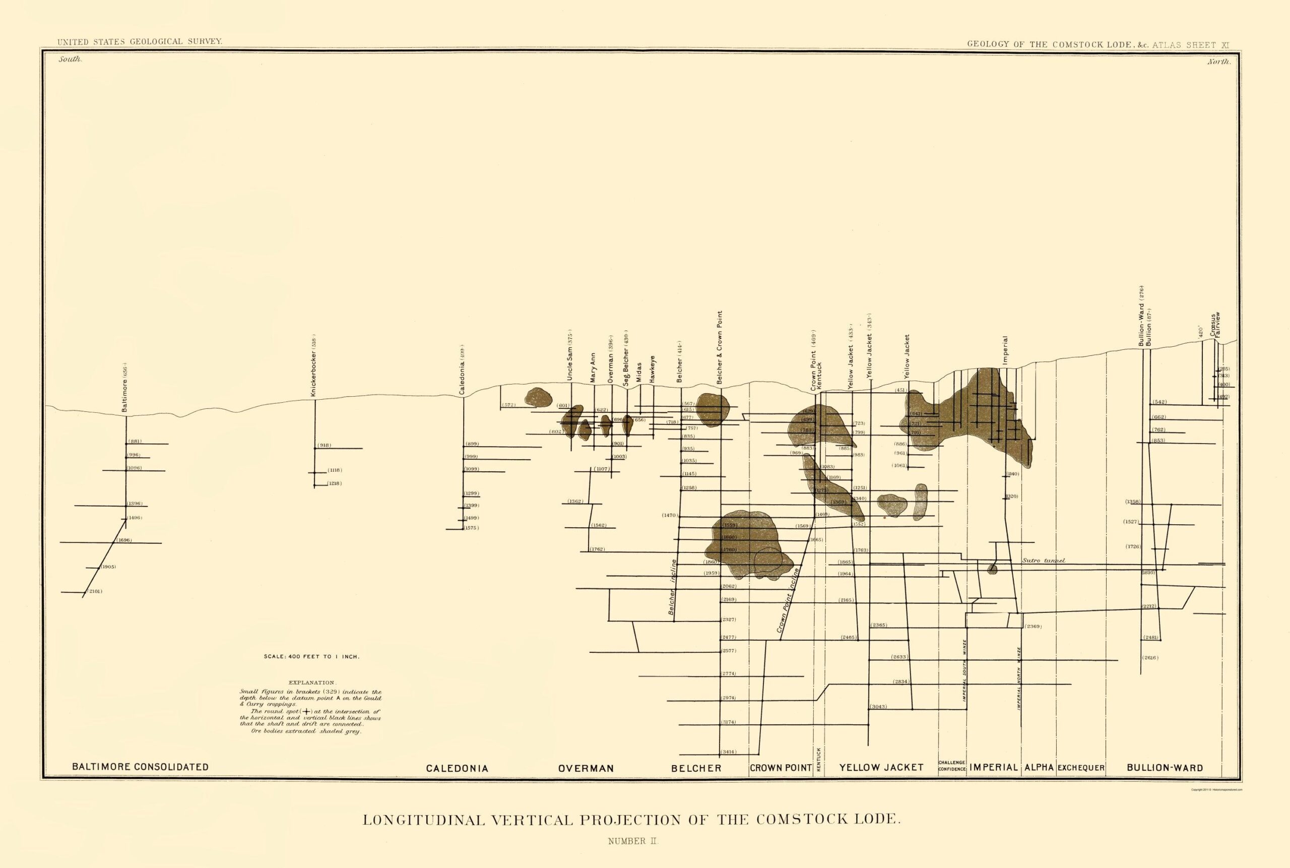
Becker’s maps make the problem visible better than any explanation can. One plate shows mine workings in plan, with separate colors tracing different levels and companies. Another presents a long vertical projection of the Comstock, placing the major claims and shafts against depth and geology.
The vertical projection is especially useful because it destroys the simple image of a mine as one straight hole under one building. Baltimore Consolidated, Caledonia, Overman, Belcher, Crown Point, Yellow Jacket, Imperial, Alpha, Exchequer, and Bullion-Ward appear along the lode with levels stacked beneath them. The Sutro Tunnel cuts across the deeper landscape. Ore bodies swell, narrow, and occur at different depths. The legal property problem followed this uneven geology.
For a nineteenth-century mining company, the real estate that mattered most might be invisible from the surface. A modest piece of hillside containing the apex of a productive vein could carry rights to mineral ground extending far below neighboring property.
The Comstock Helped Create a Specialized American Property Law
The disputes beneath Virginia City were part of a wider western problem. Mining camps from Nevada to Colorado and Montana struggled with veins that ignored rectangular property boundaries. Federal courts and, eventually, the U.S. Supreme Court spent decades defining the meaning of apexes, side lines, end lines, and extralateral rights.
The basic logic had grown out of miners’ experience. If the value lay in a vein rather than in the surface soil, a claimant who discovered and located that vein expected to be able to follow it as it dipped into the mountain. What appeared sensible from the perspective of a miner could look strange from the perspective of ordinary real estate law.
Virginia City therefore had two overlapping systems of place. Above ground were streets, houses, hotels, stores, churches, and surveyed lots. Below ground were veins, levels, claim extensions, projected planes, drifts, shafts, and disputed ore bodies. A legal boundary at the surface could be only the beginning of the argument.
Conclusion
The Comstock’s riches forced surveyors, miners, judges, and lawmakers to answer a deceptively simple question: what exactly did it mean to own a mine?
The answer could not always be drawn as a vertical box beneath a surface claim. Ownership followed geology, and geology refused to cooperate with straight lines. That is why a judge in 1867 could order nine men into the Savage workings to inspect a dispute that began near a blacksmith shop on C Street, and why company archives filled with deeds, title abstracts, surveys, and maps.
Virginia City’s streets are the landscape visitors see today. In the nineteenth century, however, some of the most valuable property lines in town existed far below them, measured in darkness against rock that no courthouse could bring into the light.
Sources
Primary and Contemporary Sources
Thornburgh v. Savage Mining Company. U.S. Circuit Court, District of Nevada, 1867. 23 F. Cas. 1113, Case No. 13,986.
Becker, George F. Geology of the Comstock Lode and the Washoe District. U.S. Geological Survey Monograph 3. Washington: Government Printing Office, 1882.
Becker, George F. Atlas to Accompany the Geology of the Comstock Lode and the Washoe District. U.S. Geological Survey, 1882.
Archival and Institutional Sources
University of Nevada, Reno Special Collections and University Archives. Ophir Silver Mining Company Records, NC56.
University of Nevada, Reno Special Collections and University Archives. Savage Mining Company Records, NC62.
University of Nevada, Reno Special Collections and University Archives. Union Consolidated Silver Mining Company Records, NC87.
University of Nevada, Reno Special Collections and University Archives. Mexican Gold and Silver Mining Company Records, NC59.
University of Nevada, Reno Special Collections and University Archives. Allison Bowers Papers / mining-property complaint materials, NC212.
University of Nevada, Reno Special Collections and University Archives. Consolidated Virginia Mining Company Records, NC99.
David Rumsey Map Collection. George F. Becker, Comstock Mine Maps from Geology of the Comstock Lode and the Washoe District, 1882.